About AlpineQuest Explorer Lite
No advertisements ~ No data sharing & monetization ~ No analytics ~ No third party libraries AlpineQuest is the complete solution for all outdoor activities and sports , including hiking, running, trailing, hunting, saili
No advertisements ~ No data sharing & monetization ~ No analytics ~ No third party libraries
AlpineQuest is
the complete solution for all outdoor activities and sports , including hiking, running, trailing, hunting, sailing, geocaching, off-road navigation and much more.
You can access and store locally a large range of
on-line topographic maps, which will remain available even while being out of cell coverage. AlpineQuest also supports many
on-board file-based raster map formats.
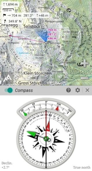
By using the GPS and the magnetic sensor of your device (with compass display), getting lost is part of the past:
you are localized in real-time on the map , which can also
be oriented to match where you are looking at.
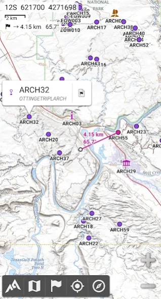
Save and retrieve unlimited
placemarks , share them with your friends.
Track your path, get
advanced statistics and
interactive graphics . You won’t have anymore questions about what you can accomplish.
By staying fully operational out of cell coverage (as often in mountain or abroad), AlpineQuest assists you in all your desires of deep wilderness exploring…
Don’t hesitate, use this Lite version right now for free!
PLEASE report suggestions and issues on our dedicated forum https://www.alpinequest.net/forum (no registration needed, all questions answered) and not in comments.
Key features are (for full version):
★★
Maps ★★
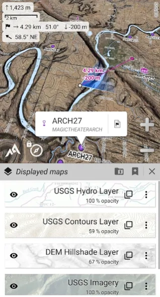
• Built-in
online maps (with
automatic local storage ; road, topo and satellite maps included) and
online layers (road names, hillshade, contours);
• Get more online maps and layers in one click from the included community maps list (all major worldwide maps and many local topo maps);
• Complete
area storage of online maps for off-line use;
•
On-board offline maps support (raster) including
KMZ Overlays, OziExplorer OZFx2, OZFx3 (partly) and calibrated images, GeoTiff, GeoPackage GeoPkg, MbTile, SqliteDB and
TMS zipped tiles (visit our website to get MOBAC, the free map creator);
•
QuickChart Memory Map support (.qct maps only, .qc3 maps not compatible);
• Built-in
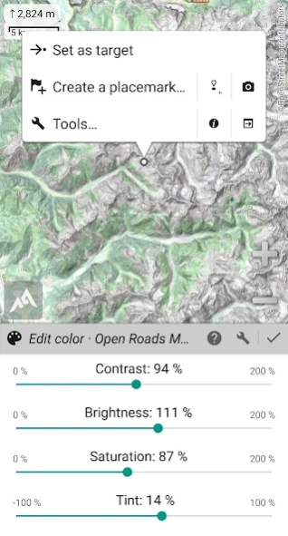
image calibration tool to use any scan or picture as a map;
•
Digital elevation model on-board storage (1-arcsec SRTM DEM) and support for
HGT elevation files (both 1-arcsec and 3-arcsec resolutions) allowing display of
terrain ,
hillshade and
steep slopes ;
•
Polar maps (Arctic and Antarctic) support;
• Multiple
maps in layers display, with per-map opacity/contrast/color/tint/blending control.
★★
Placemarks ★★
• Create, display, save, restore
unlimited number of items (waypoints, routes, areas and tracks);
• Import/export
GPX files,
Google Earth KML/KMZ files and
CSV/TSV files;
• Import
ShapeFile SHP/PRJ/DBF, OziExplorer WPT/PLT, GeoJSON, IGC tracks, Geocaching LOC waypoints and export
AutoCAD DXF files;
• Save and share online locations with other users using Community Placemarks;
•
Details ,
advanced statistics and
interactive graphics on various items;
• Time Controller to replay time-tagged tracks.
★★
GNSS Position / Orientation ★★
• On-map geolocation using device GNSS receivers (GPS/Glonass/Galileo/…) or Network;
• Map orientation,
compass and target finder;
• Built-in
GNSS/Barometric track recorder (long tracking capable, running in a separate and light process) with battery level and network strength recording;
• Proximity alerts and leave path alerts;
• Barometer support (compatible devices).
★★
And more ★★
• Metric, imperial, nautical and hybrid distance units;
• Latitude/Longitude and grid coordinate formats (WGS, UTM, MGRS, USNG, OSGB, SK42, Lambert, QTH, …) with on-map grids display;
• Ability to import hundreds of coordinate formats from https://www.spatialreference.org;
• …
Previous Versions
Here you can find the changelog of AlpineQuest Explorer Lite since it was posted on our website on 2015-04-24 03:00:00.
The latest version is 2.3.8 and it was updated on 2024-04-19 18:47:48. See below the changes in each version.
AlpineQuest Explorer Lite version 2.3.8
Updated At: 2024-03-26
Changes: 2.3.8
• Added ability to backup and restore all the application data into or from a single file;
• Added ability to display arrows, distances and ETE along the real-time location and compass heading lines (to be activated in the application settings);
• Added new slope unit (glide ratio);
• And more.
AlpineQuest Explorer Lite version 2.3.7c
Updated At: 2024-02-05
Changes: 2.3.7c
• Added new track recorder automatic frequency based on current speed;
• Added new fields in the Explorer mode: mean ascent and descent speeds (using the track recorder data), North and target direction arrows (using the device magnetic sensor);
• Added new imperial distance unit using meters instead of feet;
• Added new coordinate systems (India NSF LCC, Morocco ITRF 2020, MCK-164 to MCK-170);
• Time estimation of each route legs are now displayed on the map;
• And more.
AlpineQuest Explorer Lite version 2.3.7b
Updated At: 2024-02-05
Changes: 2.3.7b
• Added duration estimation of drawn paths and routes based on the selected activity;
2.3.7a
• Added ability to set custom items in the center point popup menu;
• Added new “Quick-routing” (quick auto-routing) that skip the creation dialog;
• Added new recorded tracks graphics by months (if only one year is selected) and by activities;
• When using the BRouter offline auto-routing service, a real-time preview of the computed route is displayed as the map is moved;
• And more.
AlpineQuest Explorer Lite version 2.3.7
Updated At: 2023-11-20
Changes: 2.3.7
• Added ability to set custom items in the center point popup menu;
• Added new “Quick-routing” (quick auto-routing) that skip the creation dialog;
• Added new recorded tracks graphics by months (if only one year is selected) and by activities;
• When using the BRouter offline auto-routing service, a real-time preview of the computed route is displayed as the map is moved;
• And more.
AlpineQuest Explorer Lite version 2.3.6c
Updated At: 2023-10-12
Changes: 2.3.6
• Added ability to set custom fields in the top Explorer mode bar;
• Added new Explorer mode fields: instant slope, terrain slope, approximate remaining battery time, done so far energy and power;
• Added ability to measure distance and elevation gain between two points of a path;
• Added mean battery consumption, overall cell network coverage, developed energy and power in recorded tracks statistics;
• Recorded track events are now displayed on the map at higher scales;
• And more
AlpineQuest Explorer Lite version 2.3.5
Updated At: 2023-09-02
Changes: 2.3.5
• Added ability to specify a background color for dashed paths and tracks;
• Added ability to rename workspaces;
• Added mils based slope units;
• While recording a track, the “Done so far” statistics reset when starting a new activity;
• Various improvements and bug fixes...
AlpineQuest Explorer Lite version 2.3.4
Updated At: 2023-05-07
Changes: • Added global statistics, graphics and filters when displaying recorded tracks;
• Added activities for recorded tracks, displayed in various colors and filterable in the recorded tracks folder;
• Tracks events are now displayed with a graphical progress line;
• In the auto-routing tool, long-pressing the “Delete” button now deletes the last segment entirely;
• And more...
AlpineQuest Explorer Lite version 2.3.3d
Updated At: 2023-01-23
Changes: The complete list is available in the changelog inside the application.
• Added ability to import multiple maps at once;
• Added ability to resize pictures when exporting KMZ files;
• The auto-routing tool now uses BRouter routings by default if available;
• And more...
AlpineQuest Explorer Lite version 2.3.0
Updated At: 2022-04-11
Changes: . New application logo;
. New menu when selecting a displayed placemark on the map;
. Placemarks are now restored after the map view is displayed in order to speed up the application startup;
. Placemarks are now displayed independently per workspaces;
. Added ability to edit the tint of maps;
. Added more long-press actions;
. Built-in maps are now displayed in workspaces;
. Improved support of Polar maps;
. Improved support of Android 11 and 12;
. Various improvements and bug fixes.
AlpineQuest Explorer Lite version 2.2.9b
Updated At: 2022-03-23
Changes: The complete list is available in the changelog inside the application.
. The track recorder also record the cell network strength (compatible devices only) and the battery level, which can be displayed in the profile view;
. Added audio waypoints allowing to record an audio track associated to a waypoint and play it from the map;
. Added global distance, time, elevation gain and area for displayed track, route and area lists in the placemark explorer;
. And much more...
Disclaimer
Official Google Play Link
We do not host AlpineQuest Explorer Lite on our servers. We did not scan it for viruses, adware, spyware or other type of malware. This app is hosted by Google and passed their terms and conditions to be listed there. We recommend caution when installing it.
The Google Play link for AlpineQuest Explorer Lite is provided to you by apps112.com without any warranties, representations or guarantees of any kind, so access it at your own risk.
If you have questions regarding this particular app contact the publisher directly. For questions about the functionalities of apps112.com contact us.